Caminito del Rey is one of those places where taking photographs feels almost unavoidable.
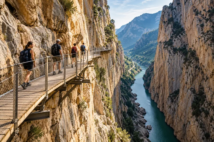
Wooden walkways cling to vertical limestone walls, the Guadalhorce River twists far below, and the narrow Desfiladero de los Gaitanes creates views that look almost too dramatic to be real.
But spending the entire walk behind a phone screen means missing much of the experience.
Learning how to experience Caminito del Rey beyond scenic photography reveals a landscape shaped by geology, water engineering, industrial ambition, wildlife, and more than a century of human interaction with an extraordinary gorge.
The modern route is linear, running north to south from the Ardales side toward El Chorro in Álora. The complete visitor journey covers roughly eight kilometres and normally takes three to four hours, including access and exit paths.
Rather than rushing from one famous photo position to another, slow down. The most memorable part of Caminito may be understanding why the walkway exists in the first place.
Start by Understanding Why Caminito del Rey Was Built
The original Caminito was not constructed as a tourist attraction.
Work began in 1901 and finished in 1905. The narrow pathway provided access for workers maintaining hydroelectric infrastructure around the Gaitanejo and El Chorro installations, allowing people and materials to move through terrain that was otherwise extremely difficult to cross.
Its famous name came later.
King Alfonso XIII crossed the route in 1921 during his visit connected with the Conde del Guadalhorce dam, after which people began calling it the Caminito del Rey – roughly, the King’s Little Path.
Knowing this completely changes the walk.
Look underneath sections of the modern boardwalk and you can still see portions of the old infrastructure. Instead of viewing them simply as frightening ruins, imagine workers using this route before modern safety railings and contemporary engineering.
The current Caminito reopened in 2015 after a major restoration project.
Pay Attention to the Geology of the Gorge
The cliffs are more than a spectacular background.
Desfiladero de los Gaitanes was carved by the Guadalhorce River through Jurassic limestone and dolomite. The protected natural site contains canyon walls reaching approximately 300 metres in height, while some sections narrow to less than ten metres.
Those dimensions become far more impressive when you stop looking only ahead.
Study the rock layers above and below the walkway. In some sections, the strata appear almost vertical, providing visible evidence of enormous geological forces that deformed the landscape before river erosion cut deeply through it.
The wider area also contains caves, underground formations, weathered cavities, and unusual erosional features. The official route even points out tafoni, hollowed rock formations visible around the Gaitanejo approach.
Try spending a few minutes looking at the rock instead of the drop.
You may discover that the geologcal story is just as dramatic as the height.
Notice How the Route Changes Between Three Different Landscapes
Caminito del Rey does not feel the same from beginning to end.
The official route moves through the Gaitanejo Gorge, the more open Hoyo Valley, and finally the dramatic Gaitanes Gorge. Forest paths and wider terrain separate some of the narrow boardwalk sections.
That variation is worth noticing.
The Gaitanejo section feels enclosed, with narrow rock walls creating an immediate sense of vertical scale. Then the landscape opens and gives your eyes a break before the route enters the final gorge.
The Gaitanes section delivers the famous high walkways, with some sections more than 100 metres above the river and rock walls rising hundreds of metres around them.
Instead of judging the entire route by which section creates the best photograph, compare how your perception changes.
A narrow canyon creates tension. An open valley feels calm. Then the final suspended walk brings the vertical landscape back dramatically.
That sequence is part of the experiance.
Look for Wildlife Instead of Constantly Looking at Your Camera
Caminito del Rey crosses the protected Desfiladero de los Gaitanes Natural Site, covering just over 2,000 hectares across Álora, Ardales, and Antequera.
The gorge supports much more life than the bare rock initially suggests.
Birds of prey recorded in the protected area include peregrine falcons, Bonelli’s eagles, eagle owls, golden eagles, and griffon vultures. Spanish ibex inhabit higher terrain, while smaller birds occupy lower areas close to the river.
That gives you a good reason to look up occasionally.
Large birds riding thermal currents can appear tiny against the scale of the cliffs, so binoculars are useful if you already carry a compact pair.
Vegetation is equally interesting. Aleppo pine, stone pine, holm oak, rockrose, and Spanish juniper occur within the protected landscape, alongside plant communities adapted to life on steep rock faces.
The scenery starts feeling much more alive when you stop treating the gorge as an empty stone corridor.
Slow Down Around the Industrial Heritage
The hydroelectric history is visible throughout the wider landscape.
Dams, channels, railway infrastructure, power installations, tunnels, and the surviving old walkway reveal how heavily humans modified this difficult terrain during the industrial era.
The original path existed because workers needed access between hydroelectric facilities. Its engineering was therefore practical before it became iconic.
You will also notice the railway repeatedly.
Its tunnels and viaducts show how engineers found different solutions to the same geographical problem: how do you move people and infrastructure through massive limestone barriers?
Try comparing those systems as you walk.
The river occupies the natural route. The railway disappears through the mountain. The Caminito hangs against its walls.
Together they create a fascinating landscape of nature and engineering rather than simply a famous walking attraction.
Treat the Suspended Walkways as Architecture
It is easy to focus entirely on the height, especially in the final gorge.
Instead, look at how the modern boardwalk adapts to the cliff.
Wooden sections follow irregular rock faces, metal supports anchor the structure, and barriers create a controlled route through terrain where a conventional trail would be impossible.
The official visitor information states that the walkway-to-walkway portion covers 2,955 metres, including about 1,550 metres of boardwalk and 1,405 metres of trail or forest track.
The final section is particularly impressive.
Here the walkway runs above surviving pieces of the earlier Caminito, allowing you to compare modern safety engineering directly with the deteriorated historical structure beneath it.
Do not rush across the most dramatic parts simply because other visitors are moving behind you.
Keep traffic flowing, but use safe widening points to absorb the relationship between cliff, walkway, river, and railway.
Plan the Logistics So They Do Not Distract From the Walk
Caminito del Rey is a one-way route, not a circular hike.
Visitors currently enter from the northern Ardales side and finish at the southern side near El Chorro in Álora. A shuttle bus connects the access areas, so transport should be part of your plan before arriving.
Reaching the control point also takes time.
The shortest approach from around El Kiosko uses a roughly 1.5-kilometre access route and takes about 20-25 minutes, while another approach is approximately 2.7 kilometres. Current rules require visitors to arrive with sufficient time before their reservation.
Do not schedule your arrival according to when your car reaches the parking area.
Schedule around when your feet need to reach the entrance.
Tickets must currently be reserved in advance through the official system. Children under eight are not permitted, and suitable secured footwear is required; flip-flops and similarly unsuitable shoes are prohibited.
Check those rules again before travelling because access arrangements can change.
Use Photography More Selectively
There is nothing wrong with taking photographs here. The route is incredibly photogenic.
The trick is deciding when photography improves the experience and when it starts replacing it.
Take the obvious wide shots early, then put your phone away for a section of the walk. Listen to the river, notice the wind moving through the gorge, and watch how sunlight hits different layers of limestone.
Try photographing details too.
Old boardwalk fragments, bolts, railway tunnels, rock textures, vegetation growing from cracks, and shadows underneath modern walkways often tell more interesting stories than another wide-angle cliff shot.
Also avoid creating bottlenecks.
Current visitor rules specifically discourage crowding, running, excessive noise, and dangerous leaning over barriers, partly to protect both visitors and the surrounding environment.
The best photo is not worth disrupting everyone else’s walk.
Give the Surrounding Landscape More Time
Finishing the Caminito does not mean you have exhausted the area.
El Chorro, the surrounding reservoirs, and the broader Desfiladero de los Gaitanes landscape provide context that is difficult to appreciate from the boardwalk alone.
The natural site was formally protected in 1989 and later received European conservation designations for birds and habitats.
Spending extra time nearby lets you see the gorge from ground level rather than only halfway up its walls.
It also helps explain why this location became important for water management, rail transport, electricity generation, recreation, and conservation.
If your timetable allows, avoid treating Caminito del Rey as a two-hour detour between Málaga attractions.
Give the surrounding area half a day or longer.
The wider scenary makes the famous walkway feel like one chapter of a much larger landscape.
Learning how to experience Caminito del Rey beyond scenic photography transforms the route from an impressive photo opportunity into a story about geology, engineering, wildlife, water, and human adaptation.
The limestone gorge explains why the landscape is so dramatic. The original walkway reveals an industrial past, while dams, railway tunnels, and hydroelectric infrastructure show how engineers responded to difficult terrain.
Meanwhile, birds of prey, cliff vegetation, and the Guadalhorce River remind you that this is still a protected natural environment.
Take plenty of photographs, but leave space between them.
Study the old pathway, watch the rock layers, listen for birds, and notice how the landscape changes between each gorge. When you experience Caminito del Rey slowly, the famous views become only one part of what makes the journey memorable.